


Written by Tadashi
Modified & Updated: 23 Sep 2024
Reviewed by Sherman Smith
When people hear the word desert, the Sahara usually comes to mind. Unsurprising, considering just how much of Africa this desert covers, and the role it’s played in human history. Can you believe the desert has been around for nearly 3 million years! One of the most surprising Sahara Desert facts, right there.
In fact, around 6,000 BC, some of the early Egyptians living there would herd cattle and build big structures in the Sahara desert. At that time, people used the barter system, trading food and animals without the exchange of money. Today the Sahara Desert’s population is around 4 million with the majority of the people living in Egypt, Libya, Mauritania, Western Sahara, and Algeria.
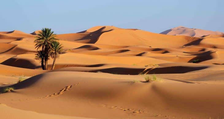
Did you know that the Sahara Desert is the world’s largest hot desert, covering around 9 million square kilometers? People believe sand dunes fill up the entire area, which is incorrect. It’s stony, barren, and devoid of rivers and streams.
Near Morocco and Western Sahara, the dunes can be found. If you want to see the biggest sand dune in the world, it is a must to visit Erg Chebbi in Morocco. However, wind storms in the Sahara can be extremely dangerous and can cause significant damage once they begin. So, if you want to see the desert for yourself, you better be careful! Although the environment makes the Sahara uninhabitable for humans, animals have lived there for many years. Several species of fox, addax, gazelle, cheetah, and goats call the Sahara Desert their home.
Want to learn more about this fascinating, magnificent piece of land? Go on and check out our collection of 40 Sahara Desert facts!
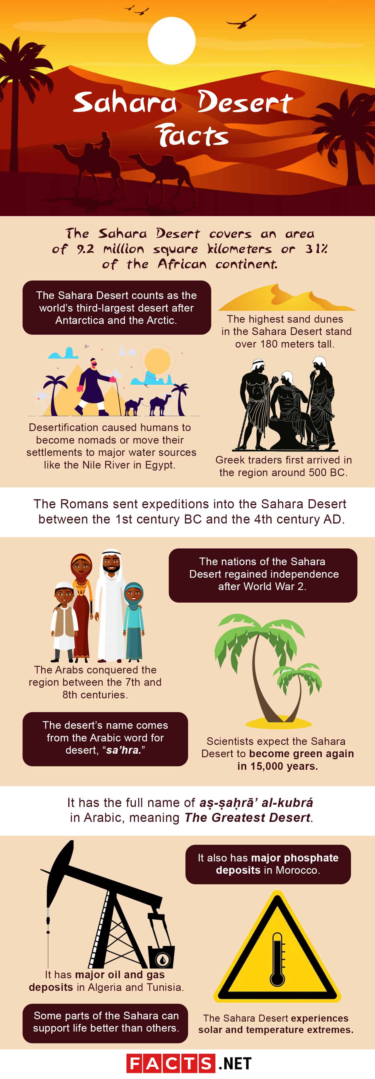
- The Sahara Desert covers an area of 9.2 million square kilometers or 31% of the African continent.
- At its widest point, the Sahara Desert stretches over a distance of 1,800 kilometers.
- At its longest point, the Sahara Desert stretches over a distance of 4,800 kilometers.
- The highest sand dunes in the Sahara Desert stand over 180 meters tall.
- The Sahara Desert counts as the world’s third-largest desert after Antarctica and the Arctic.
- Humans first settled in what would become the Sahara Desert at the end of the last Ice Age in 10,000 BC.
- Desertification in the Sahara region began around 9500 BC.
- The modern Sahara Desert had fully formed around 3400 BC.
- Desertification caused humans to become nomads or move their settlements to major water sources like the Nile River in Egypt.
- The Phoenicians began settling the Mediterranean coast in 1200 BC.
- Greek traders first arrived in the region around 500 BC.
- The Romans sent expeditions into the Sahara Desert between the 1st century BC and the 4th century AD.
- The Arabs conquered the region between the 7th and 8th centuries.
- Europeans colonized the region in the 19th century.
- The nations of the Sahara Desert regained independence after World War 2.
- Scientists expect the Sahara Desert to become green again in 15,000 years.
- The Sahara Desert has major oil and gas deposits in Algeria and Tunisia.
- It also has major phosphate deposits in Morocco.
- The desert’s name comes from the Arabic word for desert, “sa’hra.
- It has the full name of aṣ-ṣaḥrāʼ al-kubrá in Arabic, meaning The Greatest Desert.
Sahara Desert Facts Infographics
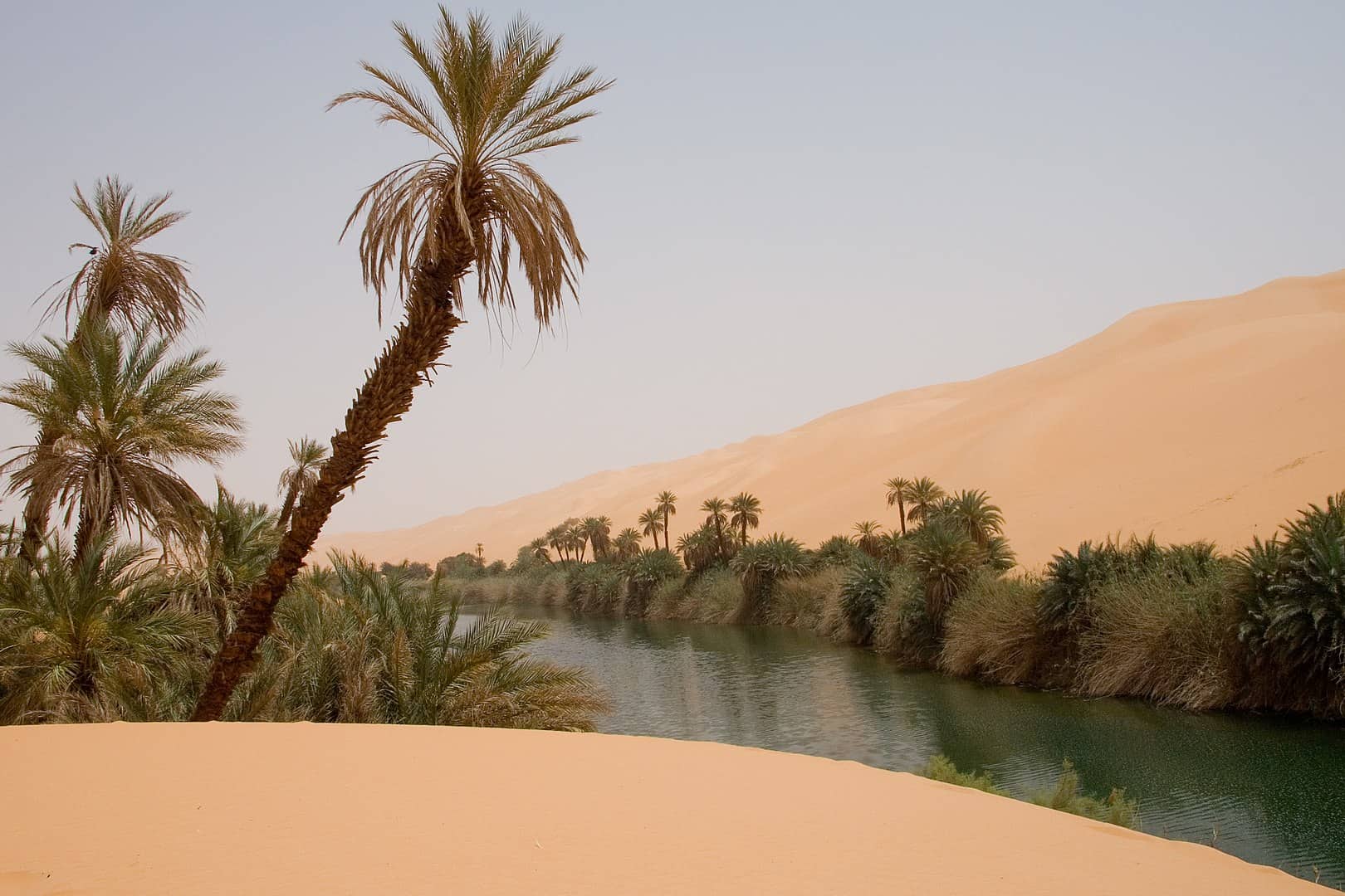
The Sahara Desert doesn’t have a uniform appearance.
Popular fiction has made people think of the Sahara as a vast region covered with sand as far as the eye can see. In reality, sand seas, or ergs as scientists call them only make up a small part of the Sahara. Instead, stone plateaus called hamadas make up most of the Saharan landscape. Other features of the landscape include gravel plains called regs, dried-up lakes and valleys, and even salt flats.
Many mountains rise out of the surrounding desert.
There’s the Air Mountains of Northern Niger, rising up to a height of 2.02 kilometers. There’s also the Hoggar Mountains in Southern Algeria, rising up to a height of 2.91 kilometers. The Saharan Atlas rises in Tunisia, while Chad and Libya share between them the Tibesti Mountains. Egypt and Sudan share the Red Sea Hills between them, while Chad has the dormant volcano Emi Koussi, the highest peak in the Sahara with a height of 3.42 kilometers.
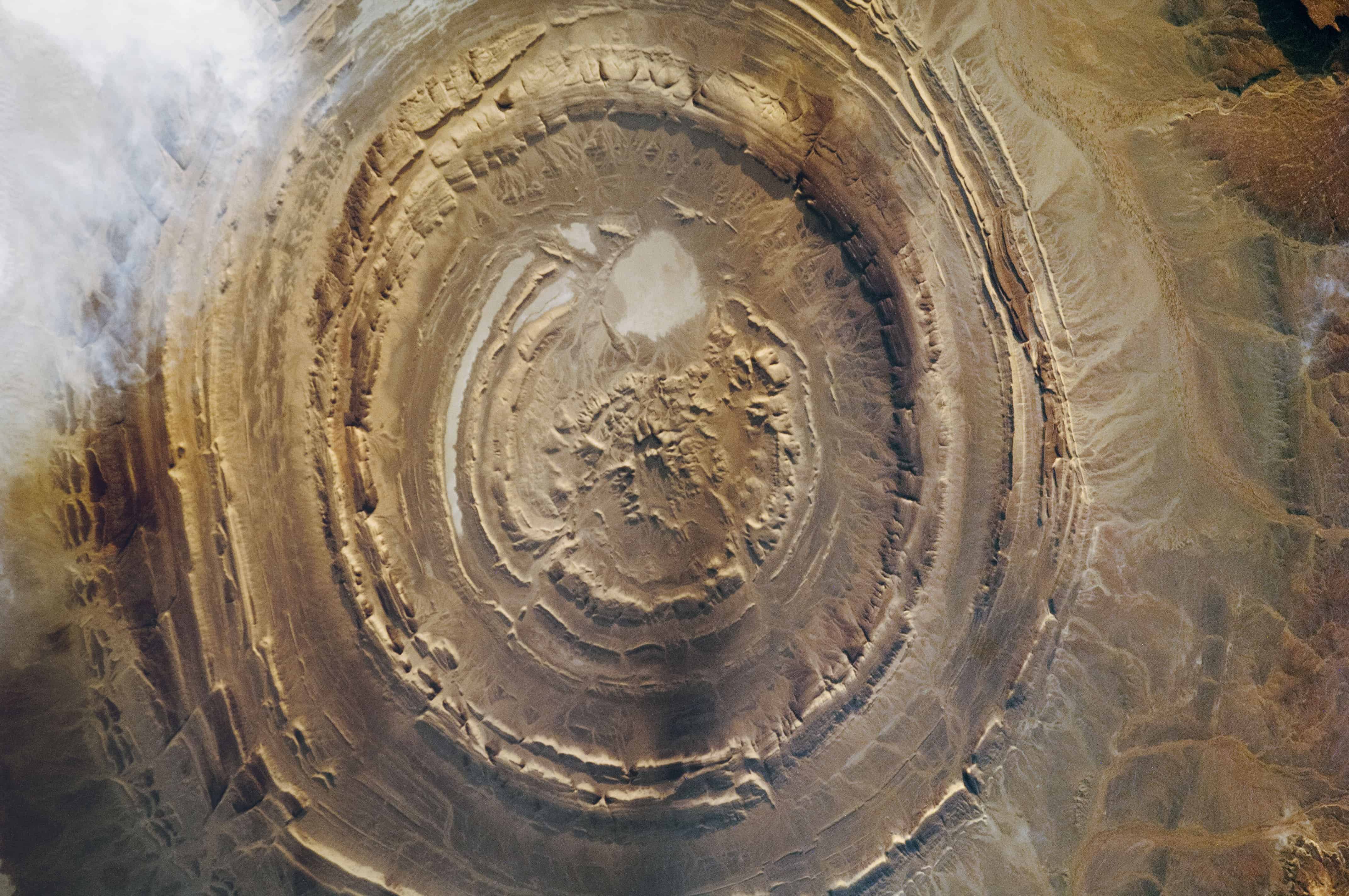
The Richat Structure makes up the most unusual feature of the Sahara Desert.
Located in Mauritania, the Richat Structure makes up a dome made from many circular layers of sedimentary rock. Deep inside, though, volcanic rock makes up the heart of the Richat Structure. Scientists first discovered it in the 1930s, and since then have struggled to find out how it formed. At first, they wondered if a meteor had caused the dome, but in the 2000s, evidence proved it wasn’t. Today, scientists think that hydrothermal waters built up the dome in the past, but research continues to prove this theory.
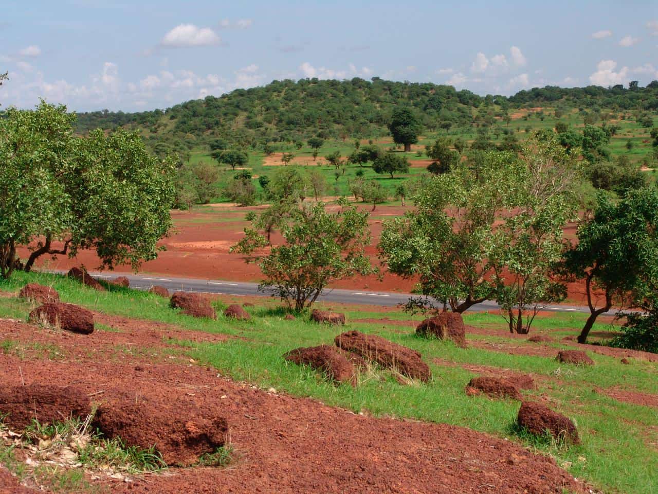
The Sahel marks the desert’s limits to the south.
The contrast between the two regions comes off as rather sharp, too. Where desert makes up the Sahara, tropical savannah makes up the Sahel, making it very green in the rainy season. That said, they do have similarities, specifically how the Sahel stretches all the way across Africa much like the Sahara does to the north. They also both share a similar root for their names, with Sahel as the Arab word for coast or shore. It has a figurative meaning, though, in this context, as only small parts of the Sahel border either the Atlantic Ocean or the Red Sea. Instead, it refers to how the Sahel makes up the southern shore of the Sahara. Other historians even argue that the region’s name comes from a different Arab word, sahl, or plain. This would reference the vast tropical grassland landscape of the region.
The Sahara Desert experiences solar and temperature extremes.
At a minimum, the desert receives an estimated 3,600 hours of sunlight every single year. In fact, parts of the eastern desert actually receive an estimated minimum of 4,000 hours of sunlight every single year. This puts the region almost at the maximum limit of sunlight any part of the Earth can receive, at 91%. Temperature-wise, average daytime temperatures in the desert usually lie around 40 degrees Celsius. At maximum, it can go even higher, with the hottest temperature on record reaching up to 47 degrees Celsius.
Nights in the desert don’t get especially cold.
A common myth connected not just to the Sahara, but to deserts in general, involves the night getting very cold. In reality, it only seems that way thanks to the heat of the day, with average nighttime temperatures only dropping to around 20 degrees Celsius. That said, exceptions do exist, such as in winter in the Sahara’s mountainous regions. There, temperatures do drop to freezing or even lower.
Rain rarely falls in the Sahara Desert.
When it does fall, it usually takes place along the Mediterranean coast, or along the edges of the Sahel. Even then, at most, it averages only 7 inches of rain in a year. As for the rest of the Sahara, on average the desert receives only one millimeter of rain in a year. In fact, in some parts of the eastern desert, the annual average drops to as low as 0.5 millimeters of rain.
The Sahara Desert does have biodiversity of its own.
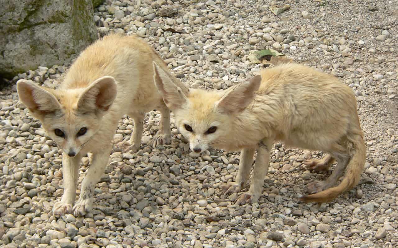
Between the heat and lack of water, people tend to see the Sahara as a lifeless wasteland. However, even in this harsh region life finds a way, with even the heart of the desert providing a home to over 500 species of plants. Several fox species also live in the desert, such as the fennec fox and Ruppell’s fox. Gazelles and antelopes also live in the desert, along with cheetahs, lizards, and snakes.
To survive in such harsh conditions, both plants and animals have evolved unique adaptations. Plants, for example, have thick stems to store water. They also can enter hibernation, and surviving getting dried up, only to turn green once again when water returns. Animals in the desert have similar adaptations, with the Addax antelope even able to go for a year without drinking water.
The Saharan silver ant makes up an insect species unique to the desert.
Again, they have unique adaptations that allow them to survive and thrive in the desert’s harsh conditions. For one thing, their body produces special heat shock proteins that prevent damage caused by quick jumps in temperature. They also can move quickly, at speeds of up to 855 millimeters per second. This might not seem like much, but the human equivalent involves moving at speeds of 200 meters per second. This makes the Saharan silver ant the fastest in the world. They need to move that fast to scavenge for food outside of their nests, usually dead or dying animals. Out in the open, they can only stay for up to 10 minutes in the Sun. Any longer and the ants will die from the heat, but with their speed, the ants can come and go quickly without dying.
Geographers divide the Sahara into several smaller areas.
Those include the woodlands of the Northern and Southern Sahara, plus the mountainous regions of the Western, Eastern, and Southern Sahara. However, most of the Sahara lies in the hyperarid central region.
Some parts of the Sahara can support life better than others.
The woodlands of the Northern and Southern Sahara see grass and trees grow and even flourish in the winter. The same goes for the mountainous regions, where higher altitudes allow clouds to form, and more rain to fall. Parts of the Eastern Sahara also support unique life forms, thriving on salt lakes that usually wouldn’t support life. However, various plant species have adapted to survive the high salt concentration, taking advantage of the rare water in the region.
The oldest mummy found in the desert predates Ancient Egyptian civilization.
Called the Tashwinat Mummy, scientists found it at Uan Muhuggiag in Libya in 1958. Scientists studying the mummy found the body of a 2½-year old boy, wrapped in leaves and antelope skin. They also found that before getting buried in the desert, the boy had had his organs removed, and preservatives injected into his body. The scientists also dated the body to around 3,000 BC, at least 1,000 years older than the first Ancient Egyptian mummies.
Ancient Humans in the Sahara Desert practiced astronomy by the 7th Millennium BC.
Archaeologists found stone circles like those at Stonehenge and similar sites in Northern Europe at Nabta Playa. Located 800 kilometers of the Great Temple at Abu Simbel in Egypt, they dated the site back to around 7.500 BC. This makes it older than Stonehenge by over 2,000 years. Studies of the site indicate the locals used it to mark the summer solstice, as well as the position of various stars over the year. In turn, this helped them keep the time, much like how a calendar would.
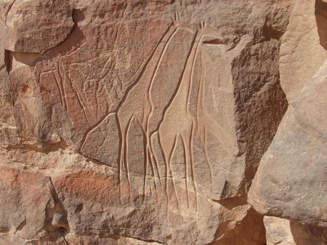
They also left behind artworks of their own.
Ancient humans in the city painted various themes into the region’s caves, themes that varied over time. The oldest rock art typically showed animals like elephants, rhinos, and even giraffes. Dating of the art confirms it comes from before the Sahara became a desert, instead of a part of the tropical savannah to the south. Younger art reflects the change in the region, showing cattle herders at the time people began traveling from oasis to oasis, as the desert formed.
Civilizations once existed in the heart of the desert in Greco-Roman times.
The Garamantes arose in Libya around 500 BC and dug deep wells to get water for their fields. This allowed them to build towns in the desert and traded with both the Greeks and Romans. Ironically, both the Greeks and Romans looked down on the Garamantes, thinking of them as uncivilized nomads. They eventually disappeared during the 7th century AD, when they exhausted the local water supply. Unable to survive in the desert anymore, the Garamantes relocated and merged their culture with those of their neighbors.
Nomadic tribes still live in the Sahara Desert today.
The Berbers make up the oldest of these tribes, going as far back as 10,000 BC. In fact, archaeologists consider the Berbers the original inhabitants of the Sahara. Today, Berber tribes live scattered across the region, across Morocco, Libya, Egypt, Mali, Tunisia, etc.
Trade once flourished across the desert.
Slaves made up an important commodity, at least until the 19th century. They were transported from Sub-Saharan Africa and sent to Mediterranean and Red Sea ports. Other important goods carried across included gold and silk from Asia, and commodities from Europe. Starting in the 19th century, though, the value of trade routes in the Sahara began to decline. The construction of the Suez Canal started it, and the spread of air travel in the 20th century further spread it up.
Europeans once considered the idea of turning the Sahara into a sea.
Here’s a strange, but true, example of Sahara Desert facts. They put the ideas forward in the 19th century, with the goal of making it easier to travel to and from West Africa. They also believed it would improve weather conditions in Europe. That said, even back then scientists questioned the effects of such proposals. Alexander Mitchinson, in particular, feared it might cause the creation of vast swamps, providing breeding grounds for pests and disease.
Modern highways cross the desert today.
Not all cargo can move by air, so plenty of trade and traffic still cross the desert today. Two ambitious construction projects even exist, one links the coastal cities from Cairo in Egypt to Dakar in Senegal through a single highway. The second project has a similar goal, only this time crossing Africa, aiming to link Tripoli in Libya with Cape Town in South Africa.
Human development of the desert poses a threat to its future.
As far back as ancient times, humans hunting large mammals like hippos in the Nile region affected the local ecosystem. Today, the development of the region such as mining phosphate or drilling for oil can affect the ecosystem even worse. Expansion of human habitation around oases can even affect both humans and the environment. Humans can exhaust the local water supply, rendering that part of the desert uninhabitable. Not just for themselves, but also for any other life in the area.
Was this page helpful?
Our commitment to delivering trustworthy and engaging content is at the heart of what we do. Each fact on our site is contributed by real users like you, bringing a wealth of diverse insights and information. To ensure the highest standards of accuracy and reliability, our dedicated editors meticulously review each submission. This process guarantees that the facts we share are not only fascinating but also credible. Trust in our commitment to quality and authenticity as you explore and learn with us.