


Written by Dita Ching
Modified & Updated: 23 Sep 2024
Reviewed by Jessica Corbett
Longitude, as one of the key components in the geographic coordinate system, plays a vital role in navigation and understanding our world. It is a fascinating concept that allows us to navigate the vast oceans, map out our planet, and even explore outer space. In this article, we will delve into 20 intriguing facts about longitude that will not only expand your knowledge but also pique your curiosity about the science and history behind it. From the incredible inventions that revolutionized navigation to the challenges faced by early explorers, join us on a journey through the world of longitude and discover the secrets of how we measure and understand Earth’s vastness. So, fasten your seatbelt, adjust your compass, and get ready to embark on a captivating exploration of longitude!
Key Takeaways:
- Longitude was a game-changer in navigation, helping sailors find their way. Thanks to smart inventions and precise measurements, dangerous journeys became safer and more certain.
- Longitude isn’t just about maps – it affects time zones, weather, and even the discovery of new lands. It’s like a secret code that helps us understand our planet and the stars above.
The concept of longitude was first proposed by ancient Greek astronomer Hipparchus in the 2nd century BC.
The idea of measuring longitude, the distance east or west of a reference point, was a significant development in navigation.
The problem of determining longitude stumped sailors for centuries.
Without an accurate method, sailors often faced hazardous and uncertain journeys.
John Harrison, an English clockmaker, invented the marine chronometer in the 18th century.
This groundbreaking device enabled accurate measurement of longitude at sea.
The prime meridian, which serves as the starting point for measuring longitude, runs through Greenwich, London, and is marked by the Greenwich Observatory.
Established in 1884, the Greenwich Meridian is now a significant landmark for navigational purposes.
The development of accurate clocks and celestial navigation methods led to the successful determination of longitude.
These advancements revolutionized travel and improved safety for sailors.
The International Date Line, located at approximately 180 degrees longitude, helps to define time zones and separates one calendar day from another.
When crossing this line, the date changes either forward or backward by one day.
Accurate longitude measurements rely on precise timekeeping.
The difference of four minutes corresponds to one degree of longitude, which equals approximately 111 kilometers at the equator.
The Earth is divided into 360 degrees of longitude, with each degree further divided into minutes and seconds.
This allows for precise location identification on the planet’s surface.
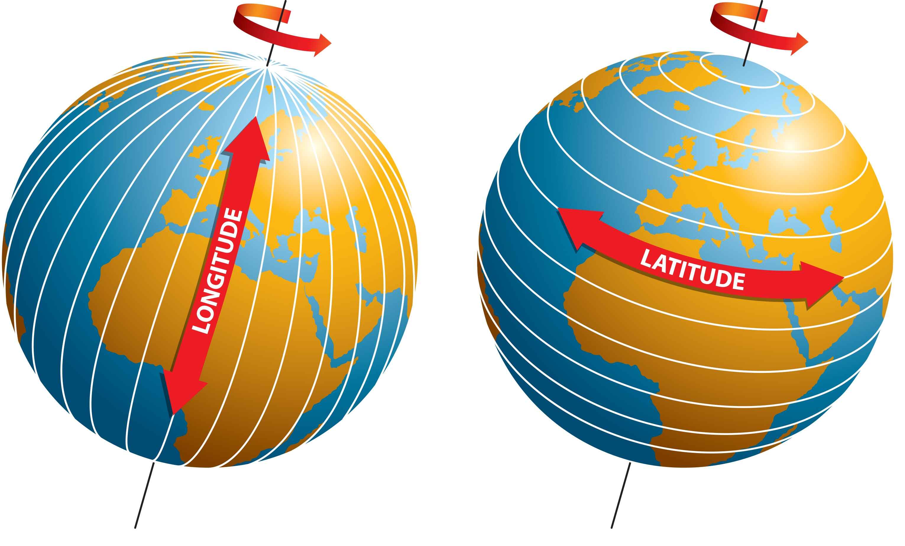
The longitude of a location indicates its east-west position relative to the prime meridian.
A positive value represents east longitude, while a negative value indicates west longitude.
The Global Positioning System (GPS), utilizing satellite technology, provides accurate longitude and latitude information for navigational purposes.
This technology has become essential for various industries, including aviation and maritime operations.
The concept of longitude greatly aided the exploration and colonization of new lands in history.
Navigators could now accurately determine their position, leading to the discovery of new territories.
Longitude is vital for accurate mapping and cartography.
By combining longitude and latitude coordinates, precise maps of the Earth’s surface can be created.
The Earth’s longitude lines converge at the North and South Poles.
At these points, all longitude lines intersect, resulting in a single longitude value.
Longitude is not only relevant on Earth but can also be used to determine the positions of celestial bodies.
Astronomers use longitude measurements to accurately locate stars, planets, and other celestial objects.
The longitude of a location affects its time zone designation.
As one moves east or west, time zones change, typically in one-hour increments.
Longitude is essential in the accurate prediction of sunrise and sunset times.
By knowing the longitude of a place, astronomers and weather forecasters can calculate exact times for these events.
Early attempts to measure longitude involved methods such as dead reckoning and lunar distance observations.
These methods were challenging and often yielded imprecise results.
The invention of the chronometer by John Harrison was a significant breakthrough in determining longitude accurately.
This portable clock allowed sailors to measure the time accurately, regardless of their location at sea.
The longitude of a location can affect its climate and weather patterns.
Changes in longitude can lead to variations in temperature, precipitation, and wind patterns.
Longitude coordinates are represented using a numerical system, with degrees ranging from 0 to 180 degrees east or west of the prime meridian.
These coordinates are essential for precise navigation and location referencing.
Conclusion
In conclusion, longitude plays a crucial role in our everyday lives, guiding us as we navigate through the world. From determining time zones to helping ships and planes find their way, understanding longitude is essential for global positioning. The concept of longitude has a rich history, dating back to ancient civilizations and evolving over time to become a fundamental aspect of modern geography.Through this article, we have explored 20 intriguing facts about longitude, from the Prime Meridian to the ingenious invention of the chronometer. We have learned about the challenges faced by early explorers and the significant impact longitude had on maritime travel and trade.Understanding longitude not only helps us navigate our physical world but also provides valuable insights into the Earth’s rotation, timekeeping, and the way we measure distance. So next time you look at a map or use a GPS, remember the importance of longitude and the fascinating history behind it.
FAQs
1. What exactly is longitude?
Longitude is a geographic coordinate that measures a location’s east-west position relative to the Prime Meridian. It is represented in degrees, ranging from 0° at the Prime Meridian to 180°E (east) and 180°W (west) at the International Date Line.
2. How is longitude measured?
Longitude is measured by determining the angle between a location and the Prime Meridian. This is achieved through various methods, including astronomical observations, GPS technology, and the use of timekeeping instruments like chronometers.
3. Why is longitude important?
Longitude is crucial for determining precise locations on Earth and for navigation purposes. It helps us establish time zones, calculate accurate distances between places, and guide ships, planes, and other vehicles when navigating the globe.
4. Who first proposed the concept of longitude?
The concept of longitude was proposed by the Greek mathematician and astronomer, Hipparchus, in the 2nd century BC. However, it was not until the 18th century that accurate methods for determining longitude were developed.
5. What is the Prime Meridian?
The Prime Meridian is the line of longitude that is designated as 0° longitude. It runs through Greenwich, London, and serves as the reference point for measuring other longitudes around the world.
6. How does longitude affect time?
Since Earth rotates 360 degrees in 24 hours, each degree of longitude represents roughly 4 minutes of time difference. This allows us to establish time zones and ensure that the time remains consistent within a given region or country.
7. Are there other lines of longitude besides the Prime Meridian?
Absolutely! Just like the Prime Meridian, there are 360 lines of longitude that encircle the Earth. These lines help us pinpoint a specific location’s east-west position, allowing for accurate navigation and mapping.
Intrigued by longitude's fascinating history and impact on our world? Continue exploring this captivating topic by delving into the mind-blowing facts about the longitude meridian, uncovering the intricacies of latitude and longitude, and immersing yourself in the captivating tales surrounding the prime meridian. Each article offers a unique perspective on these geographical marvels, providing you with a deeper understanding of how they shape our perception of time, navigation, and the world around us. So, let your curiosity guide you as you embark on this enlightening journey through the realms of longitude and latitude.
Was this page helpful?
Our commitment to delivering trustworthy and engaging content is at the heart of what we do. Each fact on our site is contributed by real users like you, bringing a wealth of diverse insights and information. To ensure the highest standards of accuracy and reliability, our dedicated editors meticulously review each submission. This process guarantees that the facts we share are not only fascinating but also credible. Trust in our commitment to quality and authenticity as you explore and learn with us.