


Written by Verena Marsden
Modified & Updated: 29 Sep 2024
Reviewed by Sherman Smith
Navigation, the art of finding one’s way from point A to point B, has been an integral part of human civilization since time immemorial. From ancient sailors using the stars to guide their ships to modern GPS systems that can pinpoint our exact location, navigation has undergone a remarkable transformation over the years.
In this article, we will delve into the fascinating world of navigation and explore 19 unbelievable facts that will leave you in awe. Whether it’s the incredible accuracy of ancient mapmakers or the awe-inspiring feats of expeditions that pushed the boundaries of human exploration, navigation has shaped the course of history and continues to play a vital role in our daily lives.
So tighten your seat belts, grab a compass, and get ready to embark on a journey filled with mind-boggling facts about map reading, orienteering, and the incredible ways we navigate our way through the world!
Key Takeaways:
- The art of navigation has evolved from ancient Polynesian star-gazing to modern GPS technology, shaping how humans explore and travel the world.
- Whether using celestial cues or GPS apps, navigation skills remain essential for outdoor enthusiasts and have played a significant role in human history.
The ancient Polynesians navigated vast oceans without the use of instruments.
Long before the advent of maps and compasses, the Polynesians relied on their deep understanding of the stars, currents, and nature to navigate across the Pacific Ocean. Through celestial navigation and observing ocean swells, they were able to pinpoint their location and successfully travel thousands of miles.
The magnetic compass was invented in ancient China.
During the Han Dynasty in China, the invention of the magnetic compass revolutionized navigation. By aligning with the Earth’s magnetic field, sailors could accurately determine their direction, making long-distance travel safer and more efficient.
The Global Positioning System (GPS) was developed by the United States Department of Defense.
In the late 20th century, the U.S. military created the GPS for accurate positioning and navigation of their troops. Today, GPS technology is widely used in various industries, from navigation systems in cars to tracking devices in smartphones.
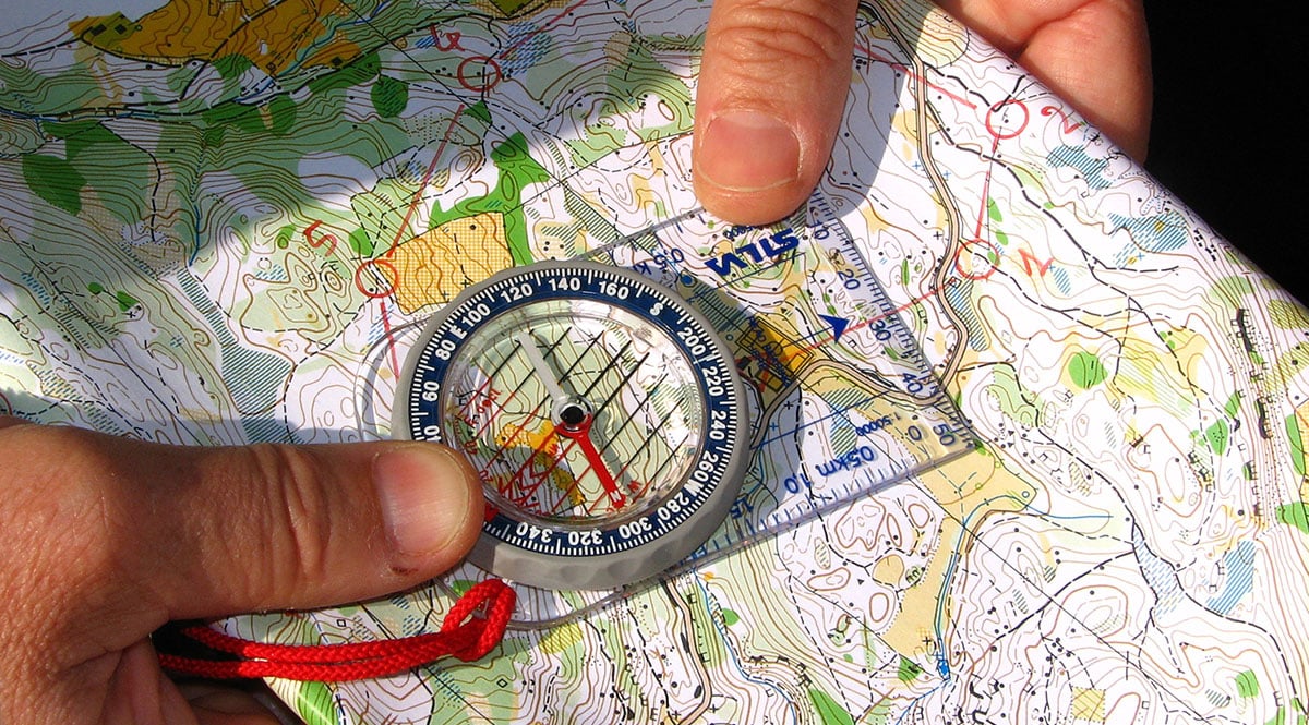
Traditional map-reading skills are still essential for navigation.
Despite technological advancements, the ability to read and interpret maps remains a fundamental skill in navigation. Understanding symbols, scales, and contours on a map can help individuals navigate unfamiliar terrain and plan routes effectively.
The art of orienteering combines navigation and physical fitness.
Orienteering is a challenging sport that combines map-reading, compass use, and physical endurance. Participants navigate through unfamiliar terrain, finding designated control points using only a map and compass.
Birds use celestial cues for navigation during migration.
Many species of birds, such as the Arctic Tern, rely on celestial cues, particularly the positions of the stars, to orient themselves during their long-distance migrations.
Inuit people navigate using an intuitive sense of their environment.
The Inuit, inhabitants of the Arctic regions, have developed an incredible ability to navigate through the icy landscapes by observing subtle changes in the environment, such as wind patterns, ice formations, and animal behavior.
Dead reckoning is a navigation technique used to estimate position.
Dead reckoning involves determining one’s current position based on a previously known position and increments of speed, bearing, and time. It is commonly used in situations where other navigation methods are not available.
The sextant is a precision instrument used in celestial navigation.
The sextant is a tool used to measure the angle between a celestial object (such as the sun or stars) and the horizon. By measuring these angles, navigators can determine their latitude and longitude, aiding in precise positioning.
The concept of longitude was developed to solve the navigation problem of determining precise location.
In the 18th century, John Harrison created the marine chronometer, a timekeeping device that allowed sailors to accurately measure longitude at sea, revolutionizing oceanic navigation.
The Transcontinental Railroad in the United States facilitated land navigation.
The completion of the Transcontinental Railroad in 1869 made overland travel across the U.S. faster and more accessible. It provided a solid physical infrastructure that allowed people to navigate across the country with relative ease.
The sextant played a crucial role in the Age of Exploration.
During the Age of Exploration, when maritime travel was expanding, the sextant helped navigators determine their position at sea, enabling new trade routes and discoveries.
Personal navigation systems, like GPS devices, have replaced traditional paper maps for many people.
With the advent of GPS technology, personal navigation systems have become prevalent, making it easier for individuals to navigate without the need for physical maps.
Today, navigation apps on smartphones have become widely popular.
Smartphone apps providing turn-by-turn navigation instructions using GPS technology have become an essential tool for many individuals, eliminating the need for standalone navigation devices.
The study of cartography focuses on the creation and interpretation of maps.
Cartography is the art and science of map-making. It involves the study of various techniques for representing geographical information and spatial relationships accurately.
Wayfinding is the ability to navigate through a physical environment without the use of maps or instruments.
Wayfinding relies on a combination of spatial awareness, landmarks, and environmental cues to navigate through unfamiliar terrain. It is commonly used in urban environments, such as airports and shopping malls.
Pioneers used a variety of methods, such as following rivers or the sun, for navigation during westward expansion.
During the westward expansion in the United States, pioneers used a combination of natural features, like rivers, and astronomical cues, like the position of the sun, to guide their journeys across the vast and unfamiliar territories.
Navigation has played a significant role in human history, enabling exploration, colonization, and trade.
Throughout history, navigation has been instrumental in the expansion and development of civilizations. It has opened up new territories, facilitated trade routes, and connected cultures.
Good navigation skills are essential for outdoor enthusiasts, hikers, and mountaineers.
For those who enjoy outdoor activities like hiking and mountaineering, having strong navigation skills is crucial. It ensures safety, helps plan routes, and allows individuals to explore new terrains confidently.
So, there you have it – 19 unbelievable facts about navigation (e.g., map reading, orienteering) that showcase the remarkable ways humans have traversed and explored the world around them. From ancient techniques to modern technological advancements, the art of navigation continues to evolve and play a vital role in our lives.
Conclusion
In conclusion, navigation is a fascinating subject with a rich history and a wide range of techniques and practices. From map reading to orienteering, the art of navigation is both a practical skill and a source of exploration and adventure. These 19 unbelievable facts about navigation shed light on the ingenuity and resourcefulness of humans when it comes to finding their way.From the ancient Polynesians navigating the vast Pacific Ocean using only the stars and natural signs, to the sophisticated GPS technology we have today, navigation has evolved and adapted to meet the needs of different cultures and eras. It is an essential skill that has guided travelers, explorers, and even everyday individuals.Whether you’re a seasoned adventurer or just curious about the world around you, learning about navigation opens up a whole new perspective. So next time you find yourself lost or simply want to explore the world, take a moment to appreciate the incredible art of navigation and the remarkable ways we have developed to find our way.
FAQs
1. What is the importance of navigation?
Navigation is crucial for finding our way in unfamiliar or vast territories. It helps us reach our destinations efficiently and safely, whether it’s by land, sea, or air.
2. How does map reading contribute to navigation?
Map reading involves interpreting and understanding maps to determine the best routes and landmarks for navigation. It allows us to visualize our surroundings and make informed decisions about our direction.
3. What is orienteering?
Orienteering is a competitive sport that combines navigation and running. Participants use maps and compasses to navigate through unfamiliar terrain and locate checkpoints in the fastest time possible.
4. How has technology impacted navigation?
Technology, such as GPS (Global Positioning System), has revolutionized navigation by providing accurate positioning and real-time directions. It has made navigation more accessible and reliable for everyday use.
5. Can anyone learn navigation?
Absolutely! Navigation is a skill that can be learned and practiced by anyone. Basic techniques, such as map reading and compass use, can be acquired through training and experience.
6. Are there any traditional methods of navigation still in use today?
Yes, traditional methods of navigation, like celestial navigation or using natural signs, are still used in certain contexts. They provide alternative ways of finding direction, especially in remote areas or when technology fails.
7. Is navigation limited to outdoor activities?
No, navigation is applicable to various aspects of life. It is used in urban settings for navigation apps, finding landmarks, or even understanding public transportation routes.
8. How can learning navigation enhance outdoor experiences?
By developing navigation skills, outdoor enthusiasts can confidently explore new places, venture off the beaten path, and navigate challenging terrains. It adds an element of self-reliance and opens up a world of adventure.
Navigation has captivated humans for centuries, from ancient techniques to modern technology. Delving deeper into this fascinating subject, you can explore the wonders of space navigation, where celestial bodies guide spacecraft through the cosmos. Alternatively, immerse yourself in the rich history of celestial navigation, used by sailors and explorers to traverse vast oceans. For those curious about cutting-edge advancements, space navigation systems offer a glimpse into the future of interplanetary travel. Each of these topics promises to expand your knowledge and appreciation for the incredible feats of human ingenuity in navigating our world and beyond.
Was this page helpful?
Our commitment to delivering trustworthy and engaging content is at the heart of what we do. Each fact on our site is contributed by real users like you, bringing a wealth of diverse insights and information. To ensure the highest standards of accuracy and reliability, our dedicated editors meticulously review each submission. This process guarantees that the facts we share are not only fascinating but also credible. Trust in our commitment to quality and authenticity as you explore and learn with us.