
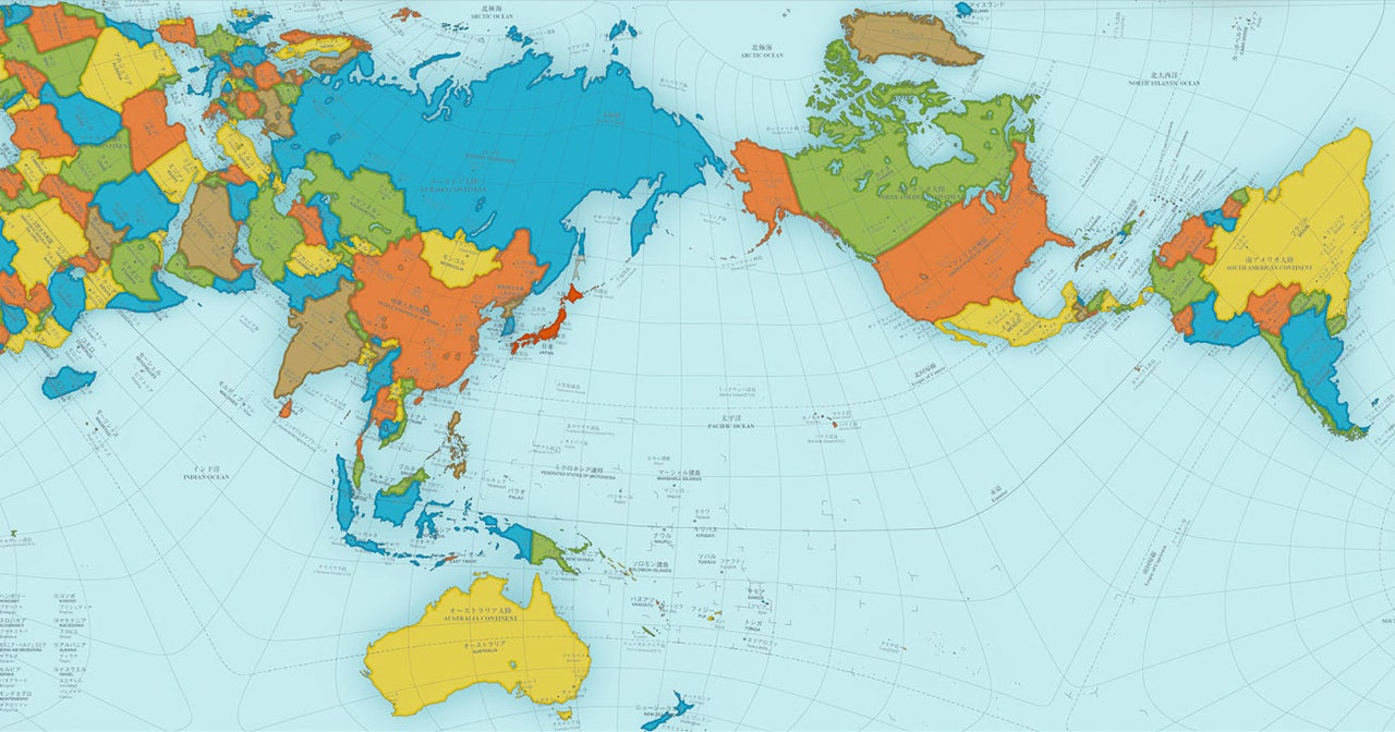
What makes the Authagraph World Map unique? The Authagraph World Map stands out because it preserves the proportions of continents and oceans more accurately than traditional maps. Unlike the Mercator projection, which distorts size near the poles, the Authagraph map divides the globe into 96 triangles, then projects them onto a tetrahedron. This method keeps shapes and sizes more realistic. Invented by Japanese architect Hajime Narukawa, this map offers a fresh perspective on our planet. It’s not just a tool for geography buffs; it’s a game-changer for educators, students, and anyone curious about the world. Ready to learn more? Let’s dive into 35 fascinating facts about this revolutionary map!
Key Takeaways:
- The Authagraph World Map is a unique and accurate representation of the globe, created by Japanese architect Hajime Narukawa. It minimizes distortion and offers a more balanced view of the world's geography.
- Its versatility makes it valuable for education, scientific research, and navigation. The map's unique projection method sets it apart from traditional maps, making it a fun and informative tool for understanding our planet.
What is the Authagraph World Map?
The Authagraph World Map is a unique way of representing our planet. Unlike traditional maps, it aims to minimize distortion, offering a more accurate view of the world.
- The Authagraph World Map was created by Japanese architect Hajime Narukawa in 1999.
- It uses a unique method of dividing the globe into 96 triangles, which are then projected onto a tetrahedron.
- This map is known for preserving the proportions of continents and oceans better than other maps.
- It won the prestigious Good Design Award in 2016.
- The map can be folded into a three-dimensional shape, making it versatile for various uses.
How Does the Authagraph Map Work?
Understanding the mechanics behind the Authagraph World Map can be fascinating. It employs a unique projection method that sets it apart from traditional maps.
- The map starts by dividing the globe into 96 equal triangles.
- These triangles are then projected onto a tetrahedron, a three-dimensional shape with four triangular faces.
- The tetrahedron is unfolded into a rectangle, creating the final map.
- This method minimizes distortion, especially near the poles.
- It allows for a more accurate representation of landmasses and oceans.
Why is the Authagraph Map Important?
The significance of the Authagraph World Map lies in its ability to provide a more accurate representation of our planet. This has various implications for education, navigation, and understanding global geography.
- Traditional maps like the Mercator projection distort the size of countries, especially near the poles.
- The Authagraph map offers a more balanced view, making it easier to compare the actual sizes of countries.
- It can be used in educational settings to teach students about geography more accurately.
- The map is also useful for scientific research, providing a better understanding of global phenomena.
- It helps in visualizing climate data, migration patterns, and other global issues.
How is the Authagraph Map Used?
The versatility of the Authagraph World Map makes it suitable for various applications. From education to scientific research, its uses are diverse.
- In classrooms, it helps students grasp the true size and shape of continents and oceans.
- Scientists use it to study climate change and other environmental issues.
- It is also used in navigation, offering a more accurate representation of routes.
- The map has been featured in various exhibitions and museums.
- It is available in different formats, including posters, globes, and digital versions.
Comparison with Other Maps
Comparing the Authagraph World Map with other traditional maps highlights its unique advantages. It stands out for its accuracy and minimal distortion.
- Unlike the Mercator projection, the Authagraph map does not exaggerate the size of regions near the poles.
- It offers a more accurate representation of the equator, which is often distorted in other maps.
- The map preserves the proportions of landmasses and oceans better than the Robinson projection.
- It provides a more realistic view of the world, making it easier to understand global geography.
- The map's unique projection method sets it apart from other traditional maps.
Fun Facts about the Authagraph Map
Learning some fun facts about the Authagraph World Map can make understanding it even more enjoyable. These tidbits offer a glimpse into its unique features and history.
- The name "Authagraph" is a combination of "authentic" and "graph."
- The map can be folded into a three-dimensional shape, making it a fun educational tool.
- It has been used in various art installations and exhibitions.
- The map is popular in Japan, where it was created.
- It has inspired other map projections and designs.
Future of the Authagraph Map
The future of the Authagraph World Map looks promising. Its unique features and accuracy make it a valuable tool for various applications.
- Researchers are exploring new ways to use the map in scientific studies.
- It is being integrated into digital platforms for easier access and use.
- The map is gaining popularity in educational settings worldwide.
- Artists and designers are using it as inspiration for new projects.
- The Authagraph World Map continues to evolve, offering new possibilities for understanding our planet.
The Final Word on the Authagraph World Map
The Authagraph World Map offers a fresh perspective on how we view our planet. Unlike traditional maps, it minimizes distortion, presenting a more accurate representation of landmasses and oceans. This innovative design has gained recognition for its ability to balance size and shape, making it a valuable tool for educators, researchers, and geography enthusiasts.
By challenging conventional map projections, the Authagraph World Map encourages us to rethink our understanding of geography. It highlights the importance of accuracy in cartography and opens up new possibilities for visualizing global data.
Whether you're a student, teacher, or simply curious about the world, the Authagraph World Map provides a fascinating glimpse into the complexities of our planet. Embrace this unique approach to mapping and discover a more accurate way to explore the world.
Frequently Asked Questions
Was this page helpful?
Our commitment to delivering trustworthy and engaging content is at the heart of what we do. Each fact on our site is contributed by real users like you, bringing a wealth of diverse insights and information. To ensure the highest standards of accuracy and reliability, our dedicated editors meticulously review each submission. This process guarantees that the facts we share are not only fascinating but also credible. Trust in our commitment to quality and authenticity as you explore and learn with us.