


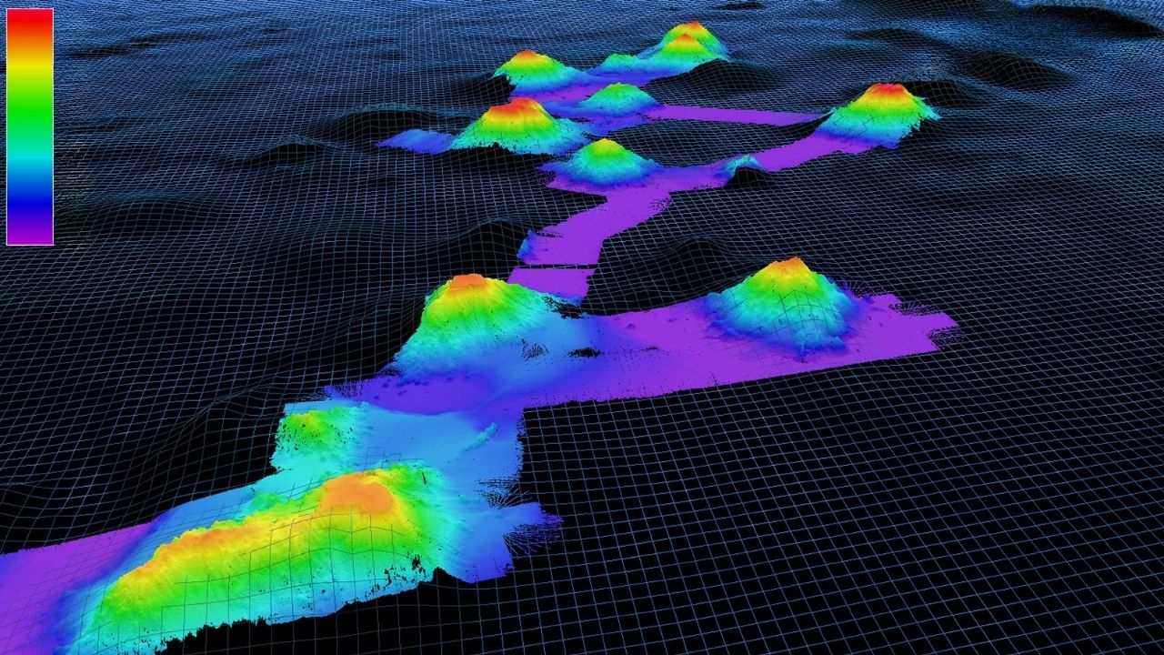
Bathymetry is the study of underwater depth of ocean floors or lake beds. Think of it as underwater topography. Bathymetric maps provide a detailed view of the underwater landscape, showing mountains, valleys, and plains hidden beneath the water's surface. These maps are crucial for navigation, laying submarine cables, and understanding marine ecosystems. Sonar technology often helps create these maps by sending sound waves to the ocean floor and measuring the time it takes for the echo to return. Satellite altimetry also plays a role, using satellites to measure the sea surface height, which indirectly reveals underwater features. Understanding bathymetry is essential for marine science, safety, and even climate studies. Dive into these 32 fascinating facts about bathymetry to learn more about this intriguing field!
What is Bathymetry?
Bathymetry is the study of underwater depth of ocean floors or lake beds. It involves mapping the underwater terrain, much like topography maps the land. This field is crucial for navigation, underwater construction, and understanding marine ecosystems.
-
Bathymetry comes from the Greek words "bathys," meaning deep, and "metron," meaning measure. It literally means "measuring depths."
-
Early bathymetric studies used weighted lines dropped from ships to measure depth. This method was called "lead-lining."
-
Modern bathymetry uses sonar technology. Ships send sound waves to the ocean floor and measure the time it takes for the echo to return.
-
Satellites can also measure sea surface height variations to infer underwater topography. This method is called satellite altimetry.
Importance of Bathymetry
Understanding the underwater landscape is vital for various reasons, from safe navigation to environmental conservation. Here are some key points highlighting its importance.
-
Bathymetric maps help ships navigate safely by avoiding underwater hazards like reefs and submerged rocks.
-
These maps are essential for laying underwater cables and pipelines, ensuring they are placed on stable ground.
-
Bathymetry aids in tsunami prediction. Underwater topography affects how tsunami waves travel and where they might hit land.
-
Marine biologists use bathymetric data to study habitats of marine life, like coral reefs and deep-sea trenches.
Bathymetric Techniques
Different techniques have evolved over time to make bathymetric mapping more accurate and efficient. Here are some of the most common methods.
-
Single-beam sonar sends a single sound wave directly beneath the ship. It’s simple but less detailed.
-
Multi-beam sonar sends multiple sound waves in a fan shape, covering a wider area and providing more detailed maps.
-
Side-scan sonar emits sound waves at an angle, useful for detecting objects on the sea floor like shipwrecks.
-
LIDAR (Light Detection and Ranging) uses laser light to measure underwater depths, often from aircraft.
Applications of Bathymetry
Bathymetry has a wide range of applications that impact various fields. Here are some notable uses.
-
Bathymetric data is crucial for coastal management, helping to prevent erosion and manage sediment.
-
It’s used in the oil and gas industry to locate potential drilling sites and ensure safe extraction.
-
Bathymetry assists in archaeological studies, helping to locate submerged ancient cities and shipwrecks.
-
Fishermen use bathymetric maps to find fish habitats and improve their catch rates.
Challenges in Bathymetry
Despite technological advancements, bathymetry faces several challenges. Here are some of the main obstacles.
-
Deep-sea mapping is time-consuming and expensive, requiring specialized equipment and ships.
-
Turbulent waters and strong currents can distort sonar signals, making data less accurate.
-
Dense underwater vegetation can interfere with sonar readings, complicating the mapping process.
-
Political and territorial disputes can limit access to certain underwater areas, restricting data collection.
Interesting Facts about Bathymetry
Bathymetry is a fascinating field with many intriguing aspects. Here are some interesting facts you might not know.
-
The Mariana Trench is the deepest part of the world's oceans, reaching about 36,000 feet deep.
-
Bathymetric data helped discover the Mid-Atlantic Ridge, an underwater mountain range that runs down the center of the Atlantic Ocean.
-
The Great Barrier Reef, the world's largest coral reef system, has been extensively mapped using bathymetric techniques.
-
Hydrothermal vents, which are underwater geysers, were discovered using bathymetric data.
Future of Bathymetry
The future of bathymetry looks promising with advancements in technology. Here are some trends and innovations to watch.
-
Autonomous underwater vehicles (AUVs) are being developed to map the ocean floor more efficiently and at greater depths.
-
Machine learning algorithms are being used to analyze bathymetric data, making it easier to identify patterns and anomalies.
-
Crowdsourced bathymetry is gaining traction, where data from recreational boaters is used to improve maps.
-
High-resolution bathymetric maps are being integrated with virtual reality to create immersive underwater experiences.
Bathymetry in Popular Culture
Bathymetry has even made its way into popular culture. Here are some examples.
-
The movie "Titanic" used bathymetric data to locate the sunken ship and create accurate underwater scenes.
-
Video games like "Subnautica" use bathymetric principles to design realistic underwater worlds.
-
Bathymetric maps are often featured in documentaries about ocean exploration and marine life.
-
Artists and designers use bathymetric data to create stunning visual representations of underwater landscapes.
The Depths of Understanding
Bathymetry isn't just about measuring ocean depths. It reveals hidden landscapes, from towering underwater mountains to vast plains. These maps help scientists understand ocean currents, marine life habitats, and even predict tsunamis. Knowing the seafloor's shape aids in safe navigation and laying underwater cables.
Technology like sonar and satellite altimetry has revolutionized how we map the ocean floor. Yet, despite advancements, much of the ocean remains unexplored. This mystery drives ongoing research and discovery.
Understanding bathymetry is crucial for environmental conservation, resource management, and scientific exploration. It connects us to the vast, unseen world beneath the waves, reminding us of the ocean's importance and the need to protect it.
So next time you look at the sea, remember there's a whole world beneath, waiting to be explored and understood. Dive deep into the wonders of bathymetry!
Was this page helpful?
Our commitment to delivering trustworthy and engaging content is at the heart of what we do. Each fact on our site is contributed by real users like you, bringing a wealth of diverse insights and information. To ensure the highest standards of accuracy and reliability, our dedicated editors meticulously review each submission. This process guarantees that the facts we share are not only fascinating but also credible. Trust in our commitment to quality and authenticity as you explore and learn with us.