


Written by Terese Booth
Modified & Updated: 06 Dec 2024
Reviewed by Jessica Corbett
When it comes to exploring the amazing intricacies of our planet, topography is a fascinating domain to navigate. The study of physical features and landforms on Earth’s surface, topography uncovers a wealth of information about the ever-changing landscapes that surround us. From towering mountains and expansive plains to winding rivers and deep valleys, topography provides a deep understanding of the Earth’s surface. In this article, we will delve into 19 astonishing facts about topography. Prepare to be amazed as we uncover incredible details about the world’s highest peaks, the deepest canyons, the largest deserts, and much more. So, let’s embark on this captivating journey through the fascinating world of topography.
Key Takeaways:
- Topography is the study of Earth’s surface, helping us understand how mountains, valleys, and oceans are formed. It also plays a big role in predicting natural disasters and determining climate patterns.
- Topography influences soil, biodiversity, and water resources, impacting agriculture, ecosystems, and groundwater. It also holds cultural and historical significance for local communities.
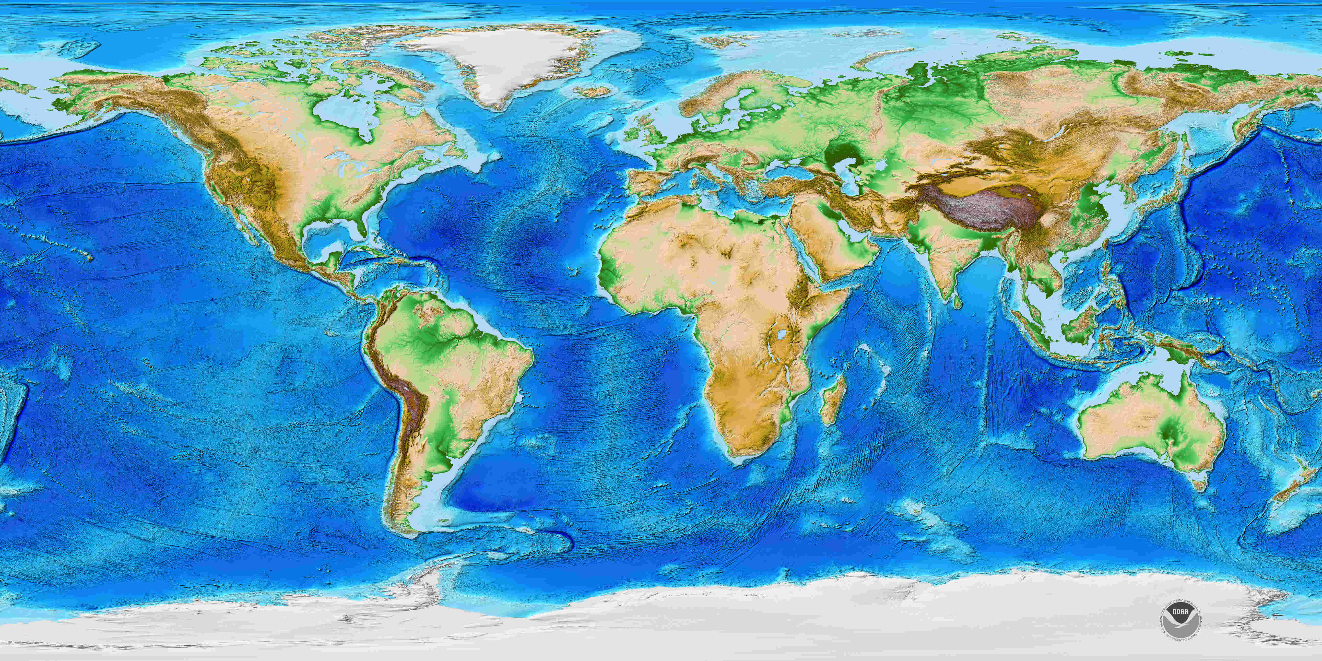
Topography is the study of Earth’s surface.
Topography is the scientific discipline dedicated to defining and representing the physical features of the Earth’s surface, such as mountains, valleys, rivers, and plains.
It helps us understand the shape of the land.
By studying topography, geographers and scientists can gain insights into how land features are formed and their impact on various ecological systems.
Topography is influenced by tectonic activity.
The movement of Earth’s tectonic plates plays a significant role in shaping the topography of the planet. Volcanic eruptions, earthquakes, and mountain-building processes contribute to the formation of diverse landforms.
The highest point on Earth is Mount Everest.
Standing at a staggering height of 29,029 feet (8,848 meters), Mount Everest in the Himalayas is the highest peak in the world and a major attraction for mountaineers.
The lowest point on Earth is the Mariana Trench.
Located in the western Pacific Ocean, the Mariana Trench reaches a depth of about 36,070 feet (10,972 meters) below sea level, making it the deepest part of the world’s oceans.
Topography is crucial for mapping and navigation.
Cartographers rely on topographic maps to accurately represent the Earth’s surface features, enabling effective navigation and providing important information for various activities like hiking, urban planning, and infrastructure development.
The study of topography helps predict natural disasters.
By analyzing topographic data, scientists can identify areas prone to landslides, flooding, and other natural hazards, allowing for better disaster preparedness and mitigation strategies.
Topography plays a role in determining climate patterns.
Mountain ranges and other topographic features influence weather patterns by affecting air circulation and precipitation. They can create rain shadows and influence the distribution of temperature and rainfall across regions.
The Dead Sea has the lowest elevation on land.
Situated between Israel and Jordan, the Dead Sea sits at approximately 1,410 feet (430 meters) below sea level, making it the lowest point on land.
The Great Barrier Reef encompasses a vast topographical area.
As the world’s largest coral reef system, the Great Barrier Reef spans over 2,300 kilometers and consists of a complex network of reefs, islands, and coral formations.
Topography affects soil composition.
The shape and slope of the land contribute to variations in soil types and fertility, impacting agricultural practices and crop yields.
The Grand Canyon is a remarkable topographical feature.
Carved by the Colorado River, the Grand Canyon in Arizona, USA, showcases the power of erosion and exposes millions of years of geological history.
Topography influences biodiversity.
Different landforms create diverse habitats, supporting a wide range of plant and animal species. Mountain ranges, wetlands, and coastal areas are examples of topographical features that foster high biodiversity.
The Gobi Desert is an example of unique topographical characteristics.
Spanning parts of northern China and southern Mongolia, the Gobi Desert features vast expanses of sand dunes, rocky formations, and sparse vegetation, reflecting the impact of topography on regional ecosystems.
The topography of the ocean floor is complex.
Underwater features like mid-ocean ridges, trenches, and seamounts contribute to the diverse topographical landscape of the ocean floor, providing habitats for marine life.
Topography can indicate areas of groundwater accumulation.
The shape and elevation of the land can affect the flow and accumulation of groundwater, influencing the availability of water resources in different regions.
The Andes Mountains form the longest topographical feature in the world.
Stretching approximately 7,000 kilometers along the western edge of South America, the Andes Mountains are a major topographical feature that influences regional climates and supports unique ecosystems.
Topography has cultural and historical significance.
Landforms and geographical features often hold cultural or historical value for local communities, shaping their traditions, livelihoods, and identities.
Innovative technologies enhance topographic mapping.
Advancements in remote sensing, aerial imaging, and satellite technology have revolutionized the way topographic data is collected and analyzed, allowing for more accurate and detailed representations of Earth’s surface.
Conclusion
In conclusion, topography is a fascinating field that reveals the intricacies of the Earth’s surface. From towering mountain ranges to vast plains and meandering rivers, topography shapes the landscapes we see around us. Understanding topography is crucial for various industries, including urban planning, agriculture, and environmental conservation. It helps us navigate and make sense of our surroundings, providing insights into the geology, climate, and human impact on a particular area. By delving into the astonishing facts about topography, we gain a deeper appreciation for the dynamic nature of our planet and the forces that have shaped it over millions of years.
FAQs
Q: What is topography?
Topography is the study and mapping of the physical features of the Earth’s surface, including terrain, elevation, and the distribution of landforms.
Q: Why is topography important?
Topography is important because it provides valuable information about the landscape, which aids in various fields such as urban planning, agriculture, and disaster management.
Q: How is topography measured?
Topography is measured using techniques such as remote sensing, geographic information systems (GIS), and ground-based surveys.
Q: What are some common landforms studied in topography?
Some common landforms studied in topography include mountains, valleys, plateaus, hills, plains, and coastal features.
Q: How does topography affect weather patterns?
Topography plays a significant role in influencing local weather patterns by affecting wind flow, precipitation, and temperature gradients.
Q: Can topography change over time?
Yes, topography can change over time due to various factors, including erosion, tectonic activity, volcanic eruptions, and human intervention.
Was this page helpful?
Our commitment to delivering trustworthy and engaging content is at the heart of what we do. Each fact on our site is contributed by real users like you, bringing a wealth of diverse insights and information. To ensure the highest standards of accuracy and reliability, our dedicated editors meticulously review each submission. This process guarantees that the facts we share are not only fascinating but also credible. Trust in our commitment to quality and authenticity as you explore and learn with us.