


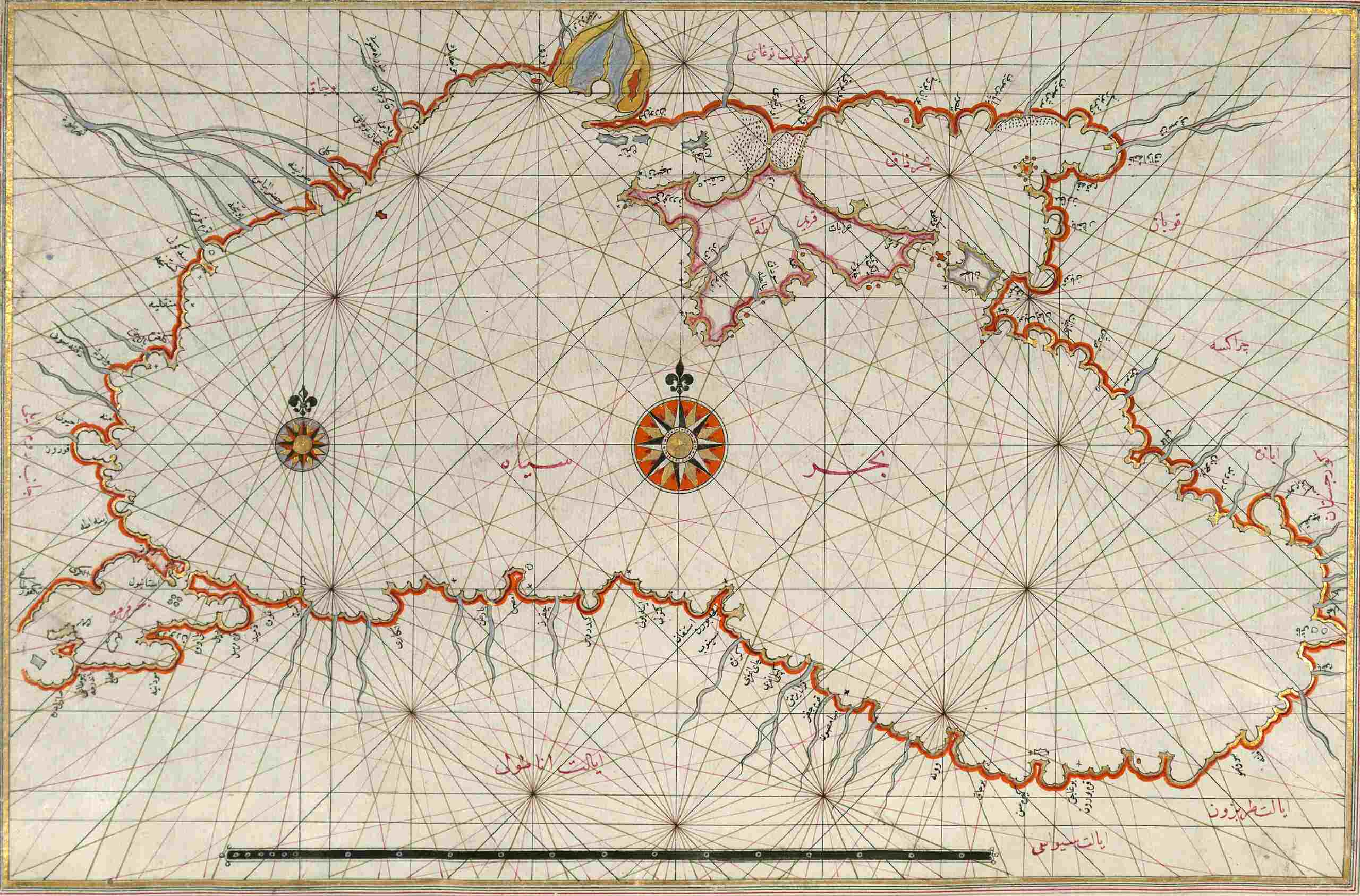
The Piri Reis Map, crafted in 1513 by Ottoman admiral and cartographer Piri Reis, stands as one of the most intriguing artifacts from the Age of Discovery. This ancient map, drawn on gazelle skin parchment, showcases detailed depictions of the New World, including parts of North and South America. What truly baffles historians is its inclusion of Antarctica, a continent not officially discovered by Europeans until 1820. How could a 16th-century map feature such accurate details? Some theories suggest advanced ancient civilizations or lost knowledge, while others attribute it to Piri Reis's meticulous compilation of various sources. Could this map hold secrets of forgotten history?
Key Takeaways:
- The Piri Reis Map, created in 1513, is a fascinating artifact from the Age of Discovery, showcasing advanced cartographic techniques and sparking debates about its depiction of Antarctica.
- This ancient map, drawn on gazelle skin parchment, provides valuable insights into historical cartography and the knowledge of early-16th-century explorers, captivating the public imagination with its mysterious elements.
The Piri Reis Map: An Ancient Marvel
The Piri Reis map, created in 1513, is one of the most intriguing artifacts from the Age of Discovery. Compiled by Ottoman Turkish admiral and cartographer Piri Reis, this map has fascinated scholars and enthusiasts alike with its detailed depictions and mysterious elements. Let's dive into the facts that make this map so captivating.
-
Creation Date
The Piri Reis map was created in 1513, making it one of the oldest post-Columbian world maps in existence. -
Cartographer
The map was compiled by Piri Reis, an Ottoman Turkish admiral and cartographer known for his meticulous work and detailed maps. -
Materials Used
Drawn on gazelle skin parchment, a common material for maps during the 16th century, the map has withstood the test of time. -
Size
The surviving portion measures approximately 35 by 24 inches, though it is believed to have been part of a larger world map. -
Significance
The map is significant for its age and detailed depiction of the New World, including North and South America, and its inclusion of Antarctica, which Europeans didn't discover until 1820.
Sources and Inscriptions
Understanding the sources and inscriptions on the Piri Reis map helps us appreciate its historical context and the knowledge it encapsulates.
-
Sources Used
Piri Reis claimed the map was based on about 20 other maps, including Portuguese, Spanish, and Arabic charts, as well as a map drawn by Christopher Columbus. -
Inscriptions
The map includes 117 place-names and 30 inscriptions, most in Ottoman-Turkish, with one in Arabic identifying the mapmaker as Piri Reis. -
Historical Context
Presented to Ottoman Sultan Selim I in 1517, the map was considered one of the most complete maps of its time.
The Mysterious Depiction of Antarctica
One of the most debated aspects of the Piri Reis map is its depiction of Antarctica, a continent not officially discovered by Europeans until centuries later.
-
Depiction of Antarctica
The map appears to show the northern coast of Antarctica, sparking much speculation about its origins. -
Connection to South America
Antarctica is depicted connected to South America, leading some historians to suggest the landmass was exaggerated for clarity. -
Historical Debate
The depiction of Antarctica has led to intense debate. Some argue it shows the continent before it was covered in ice, while others suggest it could be an island or a distorted representation. -
Charles Hapgood’s Theory
Historian Charles Hapgood proposed the map shows a prehistoric Antarctica, suggesting ancient civilizations had advanced navigational skills. However, this theory lacks concrete evidence.
Influences and Techniques
The Piri Reis map showcases a blend of influences and advanced cartographic techniques for its time.
-
Ptolemaic Influence
The map includes depictions of lands south of the Atlantic Ocean, common on maps since Ptolemy's time, indicating Piri Reis drew from existing cartographic knowledge. -
Portuguese Maps
The map includes four newly drawn Portuguese maps of Sindh, Pakistan, and other regions, highlighting the extensive use of contemporary data. -
Columbus’s Map
An inscription mentions a map drawn by Christopher Columbus, leading to speculation about the map's accuracy and the extent of Columbus's explorations. -
Historical Accuracy
Despite controversies, many scholars agree the map corresponds with the information available to early-16th-century explorers and cartographers, showcasing Piri Reis's skill.
Rediscovery and Preservation
The journey of the Piri Reis map from its creation to its rediscovery and preservation is as fascinating as the map itself.
-
Rediscovery
Rediscovered in 1929 by German theologian Gustav Deissmann while cataloging Istanbul’s Topkapi Palace library, the map was identified by orientalist Paul Calais. -
Current Location
The surviving portion is housed in the library of Topkapi Palace in Istanbul, Turkey, rarely shown to the public due to its fragile condition. -
Controversies
The map has sparked several controversies, including claims of evidence for an ancient seafaring civilization or extraterrestrial visitation, though these claims lack concrete evidence.
Cartographic Techniques and Legacy
The Piri Reis map is a testament to the advanced cartographic techniques of its time and has left a lasting legacy in the field of cartography.
-
Mercator Projection
The map uses the Mercator projection, not invented until the mid-16th century, leading to confusion about its creation date and accuracy. -
Topographic Representation
The depiction of Antarctica without its ice cap has led some historians to suggest the map was based on sources from 4,000 BCE, though this is highly speculative. -
Aerial Capabilities
The detailed topographic representation of inland areas has led some to suggest the mapmakers had aerial capabilities, a purely speculative idea unsupported by historical evidence. -
Historical Context of Antarctica
Antarctica was not discovered by Europeans until 1820. The map's depiction of the continent has led to much speculation about its creation. -
Connection to Ancient Civilizations
Some researchers suggest the map shows evidence of ancient civilizations with advanced navigational skills, though this theory remains speculative. -
Historical Significance
The map is significant for its age and role in historical cartography, representing one of the earliest attempts to create a comprehensive world map. -
Cartographic Techniques
The map demonstrates advanced techniques for its time, including the use of multiple sources and the creation of a detailed world map. -
Place-Names
The map includes 117 place-names, typical of portolan charts and easily identifiable, particularly those in Europe, Africa, South America, and the Atlantic islands. -
Inscriptions and Annotations
The map includes 30 inscriptions and annotations, providing valuable information about the people, animals, mineral wealth, and curiosities of the New World. -
Historical Authentication
Despite controversies, many scholars agree the map corresponds with the information available to early-16th-century explorers and cartographers, showcasing Piri Reis’s skill. -
Public Interest
The map has captivated the public imagination, regarded as one of the most mysterious and intriguing maps from the Age of Discovery. -
Educational Value
The map serves as an educational tool, providing insights into the cartographic techniques and historical context of the 16th century, highlighting advancements in cartography. -
Preservation Efforts
Efforts are being made to preserve the map, given its fragile condition. It is currently housed in a controlled environment to prevent further damage. -
Scholarly Debate
The map continues to be the subject of scholarly debate. While some argue it shows evidence of advanced navigational skills or extraterrestrial visitation, others see it as a testament to Piri Reis’s skill. -
Historical Context of Cartography
The map provides a glimpse into the historical context of cartography during the 16th century, highlighting the use of multiple sources and the creation of detailed world maps. -
Legacy
The Piri Reis map has left a lasting legacy in the field of cartography, inspiring research and debate, serving as a reminder of the complexities and mysteries of historical cartography.
The Legacy of the Piri Reis Map
The Piri Reis map stands as a remarkable artifact from the Age of Discovery, offering a glimpse into the cartographic skills and knowledge of the 16th century. Created by Piri Reis in 1513, this map's detailed depiction of the New World and its mysterious inclusion of Antarctica continue to spark curiosity and debate. Despite controversies and speculative theories, the map showcases the advanced techniques and extensive sources used by Piri Reis. Rediscovered in 1929, it remains housed in Istanbul's Topkapi Palace, a testament to its historical significance. The map's legacy endures, inspiring ongoing research and fascination. It serves as a valuable educational tool, highlighting the complexities and achievements of early cartography. The Piri Reis map is more than just a map; it's a window into a time of exploration and discovery, reminding us of the rich history of human curiosity and ingenuity.
Frequently Asked Questions
Was this page helpful?
Our commitment to delivering trustworthy and engaging content is at the heart of what we do. Each fact on our site is contributed by real users like you, bringing a wealth of diverse insights and information. To ensure the highest standards of accuracy and reliability, our dedicated editors meticulously review each submission. This process guarantees that the facts we share are not only fascinating but also credible. Trust in our commitment to quality and authenticity as you explore and learn with us.