

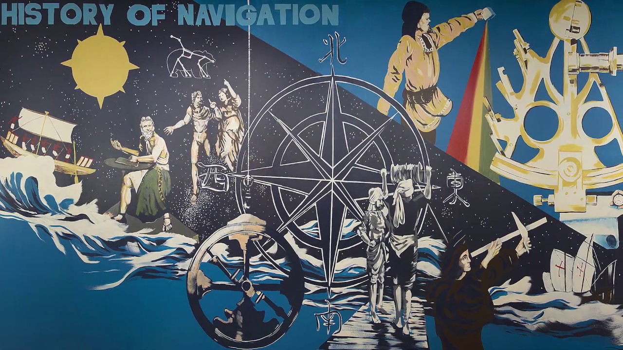
How did ancient sailors find their way across vast oceans without modern technology? The history of navigation is a tale of human ingenuity and adventure. From the earliest days, people have sought ways to traverse the seas and explore new lands. Ancient Minoans used stars to guide them, while Polynesians mastered open ocean navigation with celestial bodies and natural signs. The invention of the magnetic compass in ancient China marked a significant leap, making long-distance travel safer. Over centuries, tools like the marine sextant and sea-going clock further revolutionized navigation. Today, GPS technology offers pinpoint accuracy, yet traditional skills remain vital for many navigators.
Key Takeaways:
- Early navigation relied on natural landmarks and celestial bodies, with ancient Minoans using stars to navigate. The compass, dead reckoning, and celestial navigation revolutionized long-distance travel.
- Captain Weems simplified navigation, while ancient tools like the Antikythera mechanism and Polynesian techniques showcased early navigators' ingenuity. Modern tools like GPS have transformed navigation, but traditional skills remain essential.
Early Navigation Methods
Humans have always had a fascination with exploring the unknown. Early navigation methods were simple yet effective, relying on natural landmarks and celestial bodies.
-
Early Navigation Methods: The earliest navigation methods involved observing landmarks or watching the direction of the sun and stars. Few ancient sailors ventured out into the open sea; instead, they sailed within sight of land to navigate.
-
Ancient Minoans: The ancient Minoans, who lived on the Mediterranean island of Crete from 3000 to 1100 B.C.E., left records of using the stars to navigate. This indicates that celestial navigation was not a new concept even in ancient times.
The Compass and Dead Reckoning
As navigation evolved, tools like the compass and techniques like dead reckoning became essential for sailors.
-
Compasses: Compasses, which indicate direction relative to the Earth's magnetic poles, were being used for navigation by the 1100s C.E. and are still the most familiar navigational tools in the world.
-
Dead Reckoning: Dead reckoning involves estimating a current position based on a past position. This method factors in speed, time, and direction of travel but does not account for wind speeds or ocean currents. It was a common technique used by sailors but can be inaccurate over long distances.
Celestial Navigation and Polynesian Techniques
Navigating the open ocean required more advanced methods, such as celestial navigation and the unique techniques developed by Polynesian navigators.
-
Celestial Navigation: Celestial navigation uses the stars, moon, sun, and horizon to calculate position. It is particularly useful on the open ocean where there are no landmarks. Navigators must be familiar with different constellations at different times of the year and in various hemispheres.
-
Polynesian Navigation: The ancient Polynesians were pioneers of open ocean navigation. They used a combination of celestial navigation and piloting to travel hundreds of thousands of miles across the Pacific Ocean. They relied on oral tradition and the history of their ancestors' navigation from different islands.
-
Traditional Navigation Tools: Polynesians navigated using stars, ocean swells, the sun, the moon, and migratory birds. They also recognized different species of plants and animals native to different islands, which helped them identify the type of land ahead and its distance.
-
Stick Charts: Early Micronesian navigators called ri-metos recorded their knowledge using elaborate "stick charts" made from palm strips, coconut strips, and cowrie shells. These charts were designed to be memorized before a voyage and contained general ocean patterns and precise piloting instructions.
Technological Advancements in Navigation
The invention of new tools and techniques revolutionized navigation, making long-distance travel safer and more accurate.
-
Magnetic Compass: The magnetic compass was invented in ancient China during the Han Dynasty. It revolutionized navigation by allowing sailors to accurately determine their direction, making long-distance travel safer and more efficient.
-
Global Positioning System (GPS): The GPS was developed by the United States Department of Defense in the late 20th century. It uses satellites to provide accurate positioning and navigation, which has become widely used in various industries, including automotive and smartphone tracking.
Map Reading and the Age of Exploration
Despite technological advancements, traditional skills like map reading remained crucial, especially during the Age of Exploration.
-
Map Reading Skills: Despite technological advancements, the ability to read and interpret maps remains a fundamental skill in navigation. Understanding symbols, scales, and contours on a map helps individuals navigate unfamiliar terrain and plan routes effectively.
-
Navigation in the Age of Exploration: By the 16th century, advances in celestial navigation enabled mariners to measure the angle of the sun and stars to determine their latitude but not their longitude. This limitation made it difficult for early explorers to know their precise position at sea.
Dead Reckoning and New Instruments
Dead reckoning was a common technique, but new instruments like the marine sextant and sea-going clock improved accuracy.
-
Dead Reckoning in Ancient Times: Dead reckoning was one of the few navigation techniques available for ancient mariners. This method requires the navigator to factor in compass direction, speed, currents, and other information to track and determine the vessel's location. Errors in log keeping could result in prolonged voyages or even disaster.
-
Marine Sextant and Sea-Going Clock: New technological developments such as the marine sextant and the sea-going clock in the 18th century made ocean passages routine. These instruments allowed for more accurate measurements of celestial bodies and timekeeping, respectively.
Contributions of Captain Philip Van Horn Weems
Captain Philip Van Horn Weems made significant contributions to modern navigation, simplifying techniques and inventing new methods.
-
Captain Philip Van Horn Weems: Captain Philip Van Horn Weems was instrumental in revolutionizing modern navigation. He simplified techniques, invented new methods, and shared his knowledge through teaching. His advancements spanned maritime to aeronautic navigation and even outer space exploration.
-
Weems & Plath: The company Weems & Plath, founded by Captain Weems, continues to contribute to navigation technology. It is located in Annapolis, Maryland, and has been a significant player in the field of navigation since its inception.
-
Induction into Maritime Hall of Fame: In 2003, Captain Weems was posthumously inducted into the Maritime Hall of Fame in Annapolis. This recognition highlights his significant contributions to the history of navigation.
Ancient Tools and Techniques
Ancient tools like the Antikythera mechanism and techniques used by Mediterranean sailors showcase the ingenuity of early navigators.
-
Antikythera Mechanism: The Antikythera mechanism, discovered in a shipwreck off the Greek island of Antikythera, is an ancient analog computer used for astronomical calculations. It demonstrates the advanced understanding of celestial mechanics in ancient times.
-
Mediterranean Navigation Techniques: Sailors navigating in the Mediterranean used several techniques to determine their location, including staying in sight of land, understanding winds and their tendencies, knowledge of sea currents, and observation of the positions of the sun and stars.
Contributions of Various Cultures
Different cultures, including the Phoenicians, Greeks, Persians, and Norse, made significant contributions to navigation.
-
Phoenicians and Ancient Greeks: The Phoenicians and ancient Greeks were prominent seafaring explorers. They used various navigation techniques such as observing landmarks and celestial bodies to navigate the Mediterranean.
-
Persians and Arabians: The Persians and Arabians also made significant contributions to navigation. They developed advanced navigational tools and techniques that helped them explore and trade across vast distances.
-
Norse Navigation: The Norse people were skilled navigators who used the stars and other natural signs to navigate the seas. Their knowledge of the ocean and its currents helped them explore and settle new lands.
Austronesian and Micronesian Navigation
The Austronesian and Micronesian peoples were expert navigators, using traditional methods to travel vast distances across the Pacific.
-
Austronesian Peoples: The Austronesian peoples, including the Malays and Polynesians, were expert navigators who traveled vast distances across the Pacific using traditional methods. Their knowledge of the stars, winds, and currents was crucial for their voyages.
-
Micronesian Navigation: Micronesian navigators used stick charts and other traditional tools to navigate the Pacific. These charts were designed to be memorized before a voyage and contained detailed information about ocean patterns and piloting instructions.
Notable Voyages and Challenges
Several notable voyages and challenges highlight the importance of navigation skills in overcoming obstacles and achieving remarkable feats.
-
Tahiti-Hawaii Voyage: In 1976, a group of Polynesian canoeing enthusiasts successfully completed the Tahiti-Hawaii trip using no navigational instruments and a traditional voyaging canoe. This feat has been repeated several times, demonstrating the effectiveness of traditional navigation techniques.
-
Graveyard of the Pacific: The mouth of the Columbia River in Oregon is known as the "Graveyard of the Pacific" due to its turbulent waters and high risk of shipwrecks. This area has been a challenging place to navigate for centuries.
-
Mutiny on the Bounty: In 1789, the crew of the British ship Bounty mutinied against their leader, Lt. William Bligh. Bligh and 18 crew members were set adrift in the South Pacific with minimal navigational tools. Bligh successfully navigated over 6,500 kilometers to the island of Timor in 47 days, a remarkable feat of navigation.
-
Shackleton's Endurance: Ernest Shackleton's expedition to cross the Antarctic continent around 1915 was another notable example of navigational skill. Although the expedition did not achieve its goal, Shackleton's leadership and navigation skills helped his crew survive in one of the harshest environments on Earth.
Modern Navigation and Traditional Skills
Modern navigation tools have revolutionized travel, but traditional skills remain essential for many navigators.
-
Navigation in the 21st Century: Today, navigation is both an art and a science. Modern tools like GPS and electronic navigation systems have revolutionized the way we navigate. However, traditional map-reading skills and an understanding of celestial navigation remain essential for many navigators.
-
Evolution of Navigation Tools: From ancient stick charts to modern GPS devices, navigation tools have evolved significantly over time. Each new tool has built upon the knowledge and techniques developed by previous generations of navigators.
-
Importance of Celestial Navigation: Celestial navigation remains a crucial skill for many navigators, particularly those who venture into remote or uncharted areas. Understanding the positions of celestial bodies helps navigators determine their latitude and longitude accurately.
-
Role of Technology in Navigation: The advent of technology has transformed navigation from an art to a science. Modern tools like GPS, electronic charts, and satellite imaging have made navigation more accurate and efficient. However, traditional skills are still essential for many applications.
Navigation in Different Environments
Different environments present unique challenges and opportunities for navigation, requiring specialized techniques and knowledge.
-
Navigation in Different Environments: Navigation techniques vary depending on the environment. For example, sailors in the Mediterranean used different techniques than those in the Pacific. Understanding the specific challenges and opportunities of each environment is crucial for effective navigation.
-
Cultural Significance of Navigation: Navigation has played a significant role in human history, facilitating exploration, trade, and cultural exchange. It has also been a source of adventure and exploration, inspiring generations of sailors and explorers.
-
Continued Importance of Navigation Skills: Despite the advancements in technology, navigation skills remain essential for many professions and activities. Understanding how to read maps, use celestial navigation, and interpret weather patterns is crucial for safe and effective travel.
The Ever-Evolving Art of Navigation
Navigation has come a long way from ancient sailors using landmarks and stars to modern GPS systems guiding us with pinpoint accuracy. Early methods like dead reckoning and celestial navigation laid the groundwork for today's advanced technologies. The Polynesians and Micronesians showcased incredible skill with their traditional tools, while the invention of the magnetic compass revolutionized sea travel.
Technological advancements like the marine sextant, sea-going clock, and GPS have made navigation more precise and accessible. Yet, traditional skills like map reading and understanding celestial bodies remain crucial. Figures like Captain Philip Van Horn Weems have left a lasting impact on navigation, bridging the gap between past and present.
From ancient stick charts to sophisticated satellites, the journey of navigation reflects human ingenuity and our relentless quest to explore the unknown.
Frequently Asked Questions
Was this page helpful?
Our commitment to delivering trustworthy and engaging content is at the heart of what we do. Each fact on our site is contributed by real users like you, bringing a wealth of diverse insights and information. To ensure the highest standards of accuracy and reliability, our dedicated editors meticulously review each submission. This process guarantees that the facts we share are not only fascinating but also credible. Trust in our commitment to quality and authenticity as you explore and learn with us.