


What is a thalweg? A thalweg is the line that follows the lowest points along a riverbed or valley. This term, originating from German, combines "thal" (valley) and "weg" (way), literally meaning "valley way." It’s crucial in geography and hydrology for understanding river dynamics, erosion patterns, and even international boundaries. Rivers naturally carve out their paths, and the thalweg represents the deepest channel, guiding water flow. This concept helps in flood management, navigation, and environmental conservation. Knowing about the thalweg can also aid in resolving disputes over water rights and land borders. Dive into these 30 intriguing facts to deepen your understanding of this essential geographical feature!
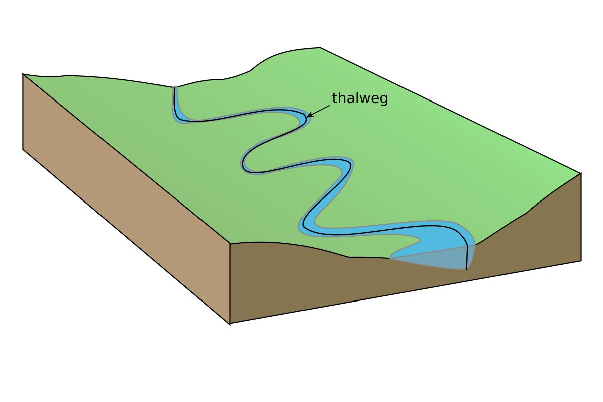
What is a Thalweg?
A thalweg is a term used in geography and hydrology to describe the line that follows the lowest points along the length of a riverbed or valley. This concept is crucial for understanding river dynamics, navigation, and even international boundaries.
- The word "thalweg" comes from German, combining "thal" (valley) and "weg" (way), meaning "valley way."
- Thalwegs are essential in determining the deepest part of a river channel, which is critical for navigation and flood management.
- In international law, thalwegs often serve as natural boundaries between countries, especially when rivers form borders.
- Thalwegs can shift over time due to natural processes like erosion, sediment deposition, and changes in water flow.
- Engineers and hydrologists use thalwegs to design and maintain infrastructure like bridges, dams, and levees.
Importance of Thalwegs in River Navigation
Navigating rivers safely and efficiently requires a deep understanding of thalwegs. They help in charting the safest and most navigable routes for boats and ships.
- Thalwegs indicate the deepest part of a river, which is usually the safest route for navigation.
- River pilots rely on thalwegs to avoid shallow areas that could damage vessels.
- Thalwegs help in planning dredging activities to maintain navigable waterways.
- Historical trade routes often followed thalwegs to ensure safe passage for goods and people.
- Modern GPS and sonar technology use thalweg data to create accurate navigation charts.
Thalwegs and Flood Management
Flood management strategies often incorporate thalweg data to predict and mitigate the impact of floods.
- Thalwegs help identify areas most likely to experience high water flow during floods.
- Floodplain mapping uses thalweg information to determine flood risk zones.
- Engineers design levees and flood barriers based on thalweg data to protect communities.
- Thalwegs can indicate potential areas for riverbank erosion during floods.
- Flood forecasting models incorporate thalweg data to improve accuracy.
Thalwegs in International Boundaries
Thalwegs play a significant role in defining natural borders between countries, especially when rivers form part of the boundary.
- The thalweg principle is often used in international treaties to define river boundaries.
- Disputes over river boundaries sometimes arise due to shifts in the thalweg.
- Thalwegs can change due to natural events like floods, leading to boundary disputes.
- Historical treaties often reference thalwegs to delineate borders.
- Modern satellite imagery helps monitor thalweg shifts and resolve boundary disputes.
Thalwegs and Environmental Studies
Environmental scientists study thalwegs to understand river ecosystems and their health.
- Thalwegs influence the distribution of aquatic habitats in rivers.
- Fish and other aquatic species often congregate along thalwegs due to deeper water and better oxygen levels.
- Thalwegs affect sediment transport, which impacts riverbank vegetation.
- Environmental restoration projects use thalweg data to design effective interventions.
- Thalwegs help identify areas of a river that may be impacted by pollution.
Thalwegs in Engineering and Construction
Engineers use thalweg data to design and build structures that interact with rivers.
- Bridge foundations are often placed based on thalweg locations to ensure stability.
- Thalwegs help determine the best sites for hydroelectric dams.
- Engineers use thalweg data to design effective riverbank stabilization projects.
- Thalwegs are crucial for planning and constructing irrigation systems.
- Thalweg information helps in designing culverts and drainage systems to manage water flow.
The Final Word on Thalwegs
Thalwegs are more than just a fancy term for the deepest part of a river channel. They play a crucial role in geography, hydrology, and even international law. Understanding thalwegs helps in flood management, navigation, and border disputes. These natural formations guide water flow, influence erosion, and shape the landscape over time. They’re essential for engineers, environmentalists, and policy-makers alike. Knowing about thalwegs can also enrich your appreciation for nature’s complexity. Next time you’re near a river, think about the unseen path the water takes. It’s not just a line on a map; it’s a dynamic feature that affects everything from local ecosystems to global politics. So, whether you’re a student, a professional, or just curious, understanding thalwegs offers valuable insights into the natural world.
Was this page helpful?
Our commitment to delivering trustworthy and engaging content is at the heart of what we do. Each fact on our site is contributed by real users like you, bringing a wealth of diverse insights and information. To ensure the highest standards of accuracy and reliability, our dedicated editors meticulously review each submission. This process guarantees that the facts we share are not only fascinating but also credible. Trust in our commitment to quality and authenticity as you explore and learn with us.